
Streets beginning with
A B C D E F G H I J K L M N O P Q R S T U V W X Y Z
You are here: Home > Places > Streets > Streets P
Streets beginning with A B C D E F G H I J K L M N O P Q R S T U V W X Y Z | Search the site |
| P | Census districts lists | references |
| The Paddock, Hove BN3 6 |
Cul-de-sac off The Droveway, built on the site of tennis courts and an associated pavilion in the 1960s. | Ke1972— |
| Paddock Field BN1 9 |
University of Brighton halls of residence on the Falmer campus. | |
| † Palace Mews | Towards the south-east coner of Jubilee Street, entered through an archway. Marked on OS maps but never included in Census returns. | OS1876, 1911 |
| Palace Place BN1 1 CA: Valley Gardens. |
Molesworth House to no 5. 5 is Grade II listed with 12-14 Pavilion Buildings1. Castle Inn was designed by John Crunden in 1766. In 1822 the ballroom was converted into a royal chapel when George IV boycotted the Chapel Royal in Prince's Place after a sermon about immorality caused him offence. The chapel was moved to Montpelier Place in 1851. Pressley's. Grade II listed2. |
Ta1854— 1HE 1380709 2HE 1380692 |
| PALMEIRA | Baron Palmeira was Sir Isaac Goldsmid, the name assumed on having the Knighthood of the Tower and Sword of Portugal bestowed on him, after a small Portuguese estate attached to the title. | |
| Palmeira Avenue, Hove BN3 3 CA: Brunswick Town. |
'Houses building' in Pa1883. 12 indentures of 1880 and 1884, deeds of covenant March 19021. 13-21 (odd) are on the B&H local list. 13 was the residence of the cricketer Sir Jack Hobbs, marked by a plaque. On this site a Middle Bronze Age tumulus—the 'Hove tumulus'—was destroyed in 1856-1857. The archaeological finds amounted to 'the most remarkable grave assemblage' ever found in Sssex: included a probable inhumation in a dug-out oak coffin, an amber cup from the Bronze Age, a Scandinavian stone battle axe, a grooved bronze dagger and a perforated whetstone pendant, which radiocarbon dating and artefact types indicate a date in C16-C15 BCE2. 14-22 (even) are on the B&H local list. 14 was the residence of the suffragette and women's rights campaigner Victoria Lidiard. Marked by a Borough of Hove plaque that was unveiled in 1996 by the Speaker of the House of Commons, Betty Boothroyd. 34 is BT Telephone Exchange. 43, Brighton and Hove New [Reform] Synagogue, designed by Derek Sharp FRIBA and opened on 10 September 1967, is 'dedicated to the glory of God and to the memory of 6 million Jews who perished in Nazi concentration camps, in honour of the dead, an inspiration to the living.' It was added to the B&H local list in 2015 but planning approval for demolition was granted August 2017. |
[1881] Pa1883— 1ESRO amsgg/AMS6621/3/8 2HER ref ES1042; Arscott (2002), quoting unidentified newspaper report (1972) |
| Palmeira Mansions BN3 2 CA: Brunswick Town. |
See 9-15 and 25-33 Church Road, Hove. | |
| ∫ Palmeira Mews, Hove | Goldsmid/Wick estate. Designed in 1869 by Goulty & Gibbins for George Vaughan1. Renamed St John's Road in c1909. | Pa1893– 1The Building News, 1969-05-14:447 |
| Palmeira Place, Hove BN3 3 CA: Willett Estate. |
Goodwood Court. | Pi1909— |
| Palmeira Square, Hove BN3 2 CA: Brunswick Town. |
'Arranged for building' in Fo1850. A bronze-age barrow, carbon-dated to 1239 BC, was unearthed at the northern end during development, which included the Hove amber cup, now in Hove Museum. The whole square, including Palmeira Court, is Grade II listed1. 1-17 are Grade II listed 1. 8 Palmeira Court was the residence towards the end of his life of Admiral Sir Percy Grant. 9 Palmeira Court was the residence towards the end of his life of Admiral Henry Blackett. 16 was the office of the Wick Estate, which administered the lettings of properties in the square and in Adelaide Crescent. 18-30 are Grade II listed 2. 28 was a residence and the deathplace in 1886 of Field Marshall Sir Richard James Dacres. Palmeira Square Gardens were laid out by 1870 in a more formal arrangement than the adjacent gardens in Adelaide Crescent and included a fountain, since removed. During WW2 the surrounding railings were removed, the gardens were opened to the public and maintenance was taken over by the Hove borough council. The northernmost secetion, oin the other side of Western Road, includes a floral clock They are on the B&H local list. The Floral Clock was created to celebrate the coronation of Queen Elizabeth II in June 1953. It was designed by G A Hyland, Hove council's director of parks and cemeteries, with a mechanism by the Edinburgh firm of Richie & Son, who made the 1903 clock in their city for the coronation of Edward VII and which may have inspired the Hove clock. Gwydyr Mansions see Holland Road. |
Fo1850— 1HE 1398646 2HE 1187581 |
| Pankhurst Avenue BN2 9 |
Originally known as Chalk Lane1. Inter-war-years social housing development (well-established by 1925) at the rear of Brighton General Hospital, although the road had been laid out at the beginning of the century with the name Queen's Park Avenue. The Pankhurst family owned land and property in the area, including the site of the former Southdown Motor Services bus garage in Freshfield Road. An air vent for the Kemp Town railway tunnel is set in the ground 'third brass' coin of Hadrian (r105-110) was found here in 19292. Nurses home for Brighton Municipal Hosptal (see Elm Grove) opened in December 1929. Covered reservoir on the north side at the western end has a capacity of 500,000 gallons. 83-89 (odd) are three-, four- and five-storey blocks of apartments in the former grounds of the Brighton General Hospital, completed in 2014. 112-120 (even) and the adjacent site on the south-east corner are owned by the Guinness Partnership, A fire gutted one block in 2020; as of 2024 the whole site, formerly comprising three three-storey apartments blocks, is due to be redeveloped. |
Pi1925— 1OS 1896-97 revision 2HER ref ES211 |
| † Paradise Cottages | At 124 Edward Street. Twenty small tenements. No thoroughfare. |
Pa1882–Pi1888 |
| † Paradise Cottages | At 25 Upper Bedford Street. Small houses. |
[1851] Ta1854–Fo1864 |
| † Paradise Piece | Pinkie in Graham Greene's Brighton Rock came from here. It cannot be traced, so may be assumed to be fictional, albeit with a description that could match a street in the Carlton Hill slums that was replaced by the Milner or Kingswood flats. | |
| † Paradise Row | From 33 Upper Bedford Street to 14 Paradise Street. |
Ba1822–Fo1864 |
| † Paradise Street | From 23 Upper Bedford Street to 33 Lavender Street. |
Fo1850–Pi1926 |
| Parham Close BN2 0 |
Post-war development along rising land off Craven Road a part of the Craven Vale estate. No properties listed in Ke1954, it now comprises two three-storey terraces, each of 12 flats. An unmade footpath at the southern end leads to Craven Wood and Race Hill. It is named after a West Sussex village and house. | Ke1954— |
| Park, The, Rottingdean BN2 7 |
Under construction 19331. Numbered 9 March 19482. | Ke1947— 1Aerial image 2 ESRO DB/D/27/280 |
| Park Avenue, Hove BN3 5 |
Two-storey detached and mainly semi-detached houses, built 1931. | Ke1947— |
| Park Close, Coldean BN1 9 |
No properties listed in Ke1947. 21 (?) was built in 1956 for the Church of Jesus Christ of the Latter Day Saints (Mormon). It closed in 1993 when the new Mormon church opened in Lewes Road and is now a private residence. |
Ke1949— |
| Park Close, Hangleton BN3 8 |
Cul-de-sac off Lark Hill. | Ke1947— |
| Park Close, Portslade BN41 2 |
Inter-war years housing. Leads to Easthill Park. | Ke1947— |
| † Park Cottages | Cul-de-sac of small tenements 'near the park' off Park Street. Numbered in Park Street by 1880. This became the western end of Freshfield Place. | [1836] Fo1850–Pa1877 |
| Park Crescent, Brighton BN2 3 CA: Valley Gardens. |
The land was previously a cricket ground, known as the Prince of Wales Ground when it was donated c1791 by the Brighton Cricket Club's patron, the future king. No matches were played here after September 1792 and the land was later sold for housing development. The crescent was designed by Amon Henry Wilds in 1829 around a park but building began only in 1849 and continued over several years. 'Houses now building" in Fo1850. (See also Union Road.) 1-16 are Grade II* listed1. 17-24 are Grade II* listed2. 24-26 were destroyed on 25 May 1943 by a bomb that passed through the Park Crescent Inn and killed two people in the houses; 24 and 26 were rebuilt in 1983. 33-48 are Grade II* listed3. 44 was the residence of dancer Violette Kaye, who was murdered in her basement flat in one of the Brighton trunk murders of 1933 (see also Kemp Street). Fuchsia Cottage 1851. 1   1. Park Crescent Inn see through the gap at 24-26 caused by wartime bombing; 2. Park Crescent from Union Road—this wall has been replaced with a higher one, planting has matured and there is now no parking |
Fo1850— 1HE 1380694 2HE 1380697 2HE 1380698 |
| Park Crescent, Portslade BN41 1 |
Cul-de-sac off Wolsleley Road. The section running south from the west end was formerly called Pitt Street; the southern part of which was built on the site of Wolseley Nurseries 1. | To1902— 1OS1950 |
| Park Crescent, Rottingdean BN2 7 |
Numbered December 19351. | Ke1947— 1ESRO DB/D/27/252 (2 plans) |
| Park Crescent Place BN2 3 |
Devonian Court two mainly red-brick five-storey apartment blocks built in the 1930s on the site of the Fryco aerated water works, which in turn had replaced the Gaiety Theatre. 6-7 is on the site of the Arcadia Cinema. |
Pa1872— 1ESRO DB/D/27/252 (2 plans) |
| Park Crescent Road BN2 3 |
Renamed and renumbered 4 October 18831. Part renamed as Park Crescent Terrace 18 October 18832. Park Crescent Road |
Pa1871— 1ESRO DB/D/27/253, DB/D/46/297 2ESRO DB/D/27/187 |
| Park Crescent Terrace BN2 3 |
'Other houses unoccupied' in Pa1871. Part of Park Crescent Road renamed and renumbered 18 October 18831. 1-6 is the Salvation Army building, opened in 2000, replacing a citadel that was designed by E J Hamilton and opened in 1883. ph 39, The Park Crescent was opened by Tamplins and dates from c1869. |
[1861] Fo1864— 1ESRO DB/D/27/187 |
| Park Gate, Hove | See Somerhill Road. | |
| † Park Gate, Preston | [1881] | |
| Park Hill BN2 0 CA: Queens Park. |
†ph 1, Spa Inn opened in 1878 and closed in 1901. Park Hill Evangelical Church was built in 1894 as St Andrew's Presbyterian Church, designed by Herbert Buckwell. It took its current name in 1943. Royal Spa opened in 1825 as the German Spa to a design by Lorraine for Dr F A Struve and was named in honour of its patron Queen Adelaide in 1835. The pump room was closed in the 1850s but continued for bottling water until 1965 and was demolished in the early 1970s. A nursery school by T R Williams was built on the site in 1978, following a local residents' campaign against a planned casino. It was gutted by arson December 1985, reconstructed and re-opened in 1987. It is Grade II listed1. |
Pa1878— 1HE 1380699 |
| † Park Place | A narrow alley of small tenements behind the east side of Mount Pleasant built around 1800 but removed in slum clearance in 1935 to allow widening of Mount Pleasant. Renumbered 20 April 18811. ph †33, Red Lion  Park Place [Brighton & Hove Museums] |
Ke1845— 1ESRO DB/D/27/189 |
| Park Rise, Hangleton BN3 8 |
Ke1947— | |
| Park Road, Coldean BN1 9 |
Laid out between Moulescoomb Wild Park and Coldean Wood/Stanmer Park. Thirty five-room semi-detached houses built in 1938, most with garages to the rear, were the first development in the Coldean area. 1   1. Park Road looking west from the junction with Coldean Lane; 2. Park Road looking east from outside no 36 |
Ke1938— |
| Park Road, Rottingdean BN2 7 CA: Rottingdean. |
Numbered December 19351. Village Hall was built in 1935. It is on the B&H local list. |
1ESRO DB/D/27/252 |
| ∫ Park Road East | Original name for Freshfield Road. Renumbered 20 April 18811. †ph 9, Railway Inn, near Kemp Town Railway Station, opened c1869 and closed in 1935. |
Pa1869–Pa1887 1ESRO DB/D/27/181 |
| Park Road Terrace BN2 0 |
†ph Red Lion Inn was built in the 1860s, demolished and rebuilt in 1965/66, partially rebuilt and converted to four houses called Parkview in the 2000s. | Pa1883— |
| ∫ Park Road West | Original name for Queen's Park Road. 'Other houses building' in Pa1873. | Pa1871–Pa1887 |
| ∫ Park Road to Race Hill | Name used in census; renamed Park Road West, then Queen's Park Road. | Census1851 |
| Park Street BN2 0 CA: Queens Park. |
The Park Street Gate was design by borough engineer and surveyor Francis J May and built in 1890. It is Grade II listed1 as are three lampposts outside nos 21 and 29 and at the corner of Eastern Road2. Queen's Park Primary School was designed by Thomas Simpson for the Brighton & Preston School Board. The tender for construction was won by Stimpson at a cost of £7,630 for the main building and £230 for extra finishings3. It is on the B&H local list. Leach Court is a group of three seven-storey Brighton council blocks, each of 36 flats, built 1969-1971 by Rice. Sloane Court takes its name from the adjacent Sloane Street. It is built on the site of †42, Victoria Baths were built at a cost of £5,743 and opened in 1887 to mark Queen Victoria's golden jubilee. Use of the baths diminished over time—but still reportedly used 15,000 times in 19784—until they were demolished c1980. Leach Court. See Eastern Road. 1  2 2 1. The Victoria Baths in Park Street; 2. the rear yard of 1 Park Street [Brighton & Hove Museums] |
Ke1845— 1HE 1380703 2HE 1380700, 1380701, 1380702 3The Builder, 22 Dec 1888:459 4RS James Gray Collection |
| Park View Road, Hove BN3 7 |
'No houses' in Pi1928-1929. | Pi1928— |
| Park View Terrace BN1 5 |
The northwards continuation of Stanford Avenue with separate consecutive numbering (1-9). All houses were designed by A C Udny for Cook2. Numbered from construction but officially 6 October 18921. |
Pa1884— 1ESRO DB/D/27/231 2ESRO DB/D/7/1958 (5 Jan 1881), 1993 (6 Apr 1881) |
| Park View Villas | In Old Shoreham Road. | To1899–To1903 (but ref to Old Shoreham Road until 1928) |
| Parkmore Terrace, Preston BN1 6 |
Cul-de-sac on the south side of and parallel to Dyke Road Drive, built above a high retaining wall that continues along the west side of Dyke Road Drive to accommodate the steep slope. | Pa1881— |
| The Parks, Portslade BN41 2 |
Steeply rising cul-de-sac off Sheppard Way. | |
| Parkside estate, Coldean | Planned by Brighton Corporation after the Second World War1, when Coldean was still in the Chailey Rural District and not within the borough—that happened in 1951. For speed and cheapness, housing was initially in pre-fabricated (prefab) form [below]. Pre-fab construction on the estate in 1946 [Brighton & Hove Museums] |
1Plan ESRO DB/D/84/11/8166 (5 Feb 1946) |
| Parochial Mews BN2 1 |
Gated terrace of four houses off Prince's Street built 2000. | |
| Parochial Terrace BN2 1 |
Terrace of eight cottages at the south-west side of Steine Gardens. | |
| Paston Place, Kemp Town BN2 1 CA: East Cliff. |
Three properties listed 'and other houses building' in Pa1871. 1 was the residence of popular novelist William Black 1879 to 1898. ph The Bristol Bar opened as the Shades of the Bristol Hotel c1839. It was refurbished by Denman & Son in 1934. Since c2012 the name over the door has been The Bristol Arms, but that seems to be ignored. 9-17 were designed by John Hill in 18714. Royal Gymnasium, also called St George's Hall, was built in 1864 by Frederick Mahomed when he moved the business from the Waggon and Horses in Church Street. Grade II listed1. Sassoon Mausoleum (see also St George's Road) was built 1892 for Sir Albert Sassoon (see 1 Eastern Terrace); his body and that of his son Sir Edward Sassoon (d 1912) were removed in 1933. The building was an air-raid shelter in World War II and added to the Hanbury Arms in 1953. Grade II listed2. BLEECO lamppost beside 1 Eastern Terrace is Grade II listed3.  Sassoon Mausoleum |
Pa1871— 1HE 1380705 2HE 1380706 3HE 1380704 4ESRO DB/D/7/1078 (18 Apr 1871) |
| PATCHAM | 'Pecca's settlement' (OE Peccan ham). [An alternative derivation is from patsham, OE for a haunch, from the shape of the hill to the west of the settlement.] An ancient manor and parish, mentioned in Domesday Book. In the reign of Edward the Confessor the substantial estate was said to have been owned by the ill-fated Harold Godwinson, who succeeded Edward as Saxon King of England in 1066. The manor, centred on Patcham Court Farm, was owned by the Nevill family from 1439 until its acquisition by Brighton Corporation in December 1925. The other manors in the parish were Moulescoomb, Patcham Court, Patcham Place and Withdean Kayliffe. Farm names: Elm, Holm, Patcham Court, Low Tong Dean, Roedale, Tongdean, Upper Roedale, Upper Varndean, Varndean, Water Hall. Formerly part of Steyning East Rural District, a small part of the parish was absorbed into the County Borough of Brighton in 1923 and a much larger part in 1928 under the Brighton Corporation Act 1927. | |
| Patcham | Conservation area, designated 1970 and extended in 1972, 1992 and 2010, comprising 16.21ha (40.05 acres). An Article 4(1) Direction was added to this area in 2012, requiring planning approvalfor most alterations to any property. | Character statement Map |
| Patcham By-Pass | Opened in 1926 to avoid congestion in the section of London Road through Patcham, which was therefore re-named Old London Road. Patcham By-Pass when first build; Old London Road is on the left. |
|
| Patcham Court | One of the manors making up the Patcham parish. Patcham Court Farm (733 acres) was owned by the Marquesses of Abergavenney from 1439 until it was bought by Brighton Corporation in December 1925; 275 acres of the farm are now designated as public access land under the Countryside and Rights of Way Act 2000. | |
| Patcham Place BN1 8 |
[1881] | |
| † Patchamcourt Road, Patcham | Renamed thus 23 January 19361. | 1ESRO DB/D/27/11 |
| Patchdean, Patcham BN1 8 |
Named 1 July 19281. | 1ESRO DB/D/27/270 |
| † Patching's Buildings | Patching: local building firm. In 1854 no fewer than four Patchings included paper-hanging among the trades on offer1. | [1826] 1Ta1854: 286-287 |
| Patchway | One of the manors that comprised the parish of Falmer. (Pecca's way?) . | |
| ∫ Patriot Place | Former name of Tilbury Place. 1 was the residnece of Edward Tilbury. |
Ke1846–Fo1861; Census1851 |
| Pavilion Buildings BN2 1 CA: Valley Gardens. |
'The New Houses forming part of Castle-square, opposite East Street, where The Lobby entrance to the Palace formerly stood'5, including Carlisle House. Indian Memorial Gate at the south entrance to the Pavilion grounds, was given to the town in 1921 by the government of India 'in commemoration of her sons who, stricken in the Great War, were tended in the Pavilion in 1914 and 1915'. (See also The Chattri off the A27.) It was opened on 26 October 1921 by the Maharajah of Patiala. The structure, walls and wooden gates are Grade II listed1. It replaced the previous gate [below}. †2 was the Brighton Athenaeum and Young Men's Literary Union, founded in 1846. 2-3 was designed for Brighton Herald by John Leopold Denman and built in 1932. The relief carvings are by Joseph Cribb. The building was later taken over by Royal Insurance and then as a bar/restaurant called All Bar One. It is now a café. It is on the B&H local list. †3, Carlisle House was the Brighton Corporation Housing Department offices in the 1930s. 4-7 built 1852-53 as terraced houses, now shops and offices. Grade II listed2. 8-11 National Westminster Bank was built 1911 (see 155-158 North Street). Grade II listed3. 12-14 were built 1852-1853 and are are Grade II listed with 5 Palace Place4. 1  2 2 3 3 1. The earlier south gate of the Pavilion; 2. Pavilion Restaurant at 6-7 Pavilion Buildings (still a restaurant); 3. The Castle Square frontage of Pavilion Buildings |
Fo1852— 1HE 1380710 2HE 1380707 3HE 1380708 4HE 1380709 5Fo1852 |
| † Pavilion Colonnade | Corner of Grand Parade and Edward Street. Number of properties in 1822-1852: 2. 2 was the residence from 1845 until his death in 1850 of Sir Martin A Shee. |
Ba1822–Fo1852 |
| Pavilion Mews BN1 1 |
Between 113 and 114 Church Street. Now gated. | [1861] |
| Pavilion Parade BN2 1 CA: Valley Gardens. |
Pre 1799. 3-4 were built c1800. Grade II listed1. 3 was the residence and consulting rooms of Sir Matthew Tierney, who died here on 28 October 1845. 5 was built late 18th century but with a new front by Wilds and Busby c1822-1830. Grade II listed3. 6-11 are from the early 19th century and Grade II listed4.. |
Ba1822— 1HE 1380711 2ODNB 3HE 1380712 4HE 1380713 5HE 1380680 |
| Pavilion Street CA: Valley Gardens. |
The southern end was formerly called Blue & Buff (1799). ph 4, The Marlborough, on the corner of Prince's Street (the address has switched between the two, despite the location of the entrance), was built in 1787 as The Golden Cross Inn. It was known as the Marlborough Hotel for many years. The proprietor in the 1820s was James Ireland, who opened Ireland's Pleasure Gardens in 1823. A pub theatre is upstairs. |
Fo1848— |
| Payne Avenue, Hove BN3 5 |
The land was acquired (after this and four other adjacent road were already laid out in plan), from William Stoneham and Rev George William Kendall on 30 July 1900 by George Payne of Brighton and Edgar Payne of Bayswater, London for £11,3451. ph 18, The George Payne was built as the Kendal Arms, designed by T H Scutt and opened in 1901 by Smithers brewery. 40 was built in 1906 as a chapel of the Society of Dependents (Cokelers), a strongly pacifist sect, associated with the Primitive Methodists and within the Arminian tradition. The chapel, also known as the Christian Meeting Room, closed in 1978 and is now a private residence. |
To1903— 1ESRO AMS5976/1 |
| Payne['s] Terrrace | See Roedale Road. | |
| Peacock Lane BN1 6 |
was a drove road, known as Drove Road, The Droveway, The Drove, Hampton's Lane and Withdean Drove. Renamed 27 July 1933 and 9 November 19331. Numbered 14 November 19502. Home Farm House see London Road (North). |
Ke1934— 1ESRO DB/D/27/25 2ESRO DB/D/27/292 |
| † Peel Place | From York Road to 1 Peel Street. Sir Robert Peel, prime minister in 1834-1835 and from 1841 to 1846, died in 1850 and is widely commemorated. His younger brother, Laurence Peel, lived and died in Brighton. 'Houses coming down' in Pi1905. †ph 1, Bedford Arms opened in the late 1850s and closed c1895. |
[1851] Fo1864–Pi1905 |
| Peel Road, Black Rock BN2 5 |
Numbered 8 December 19321. | Ke1935— 1ESRO DB/D/27/35 |
| † Peel Street | From Peel Place to 25 Ann Street, opposite the Station Works. 'Houses coming down' in Pi1905. †ph 1a was The North Star from c1854 to 1879. |
Ta1854–Pi1905 |
| ∫ Peel Terrace | Former name of Dyke Road between Seven Dials and Russell Crescent, renumbered as Dyke Road from 1872 . 7, Beresford Lodge 1851. St Alban's Lodge 1851. |
Ta1854–Pa1871 |
| Pelham Square BN1 4 CA: North Laine. |
The west side, originally Pelham Terrace, was built in 1856 and named after Lord Pelham of Stanmer (Walter John Pelham, future 4th Earl of Chichester), a Liberal politician; his widow was patron of the Lady Chichester Hospital (see New Church Road); Henry Pelham was British prime minister from 1743 to 1754. 'Small private houses now building' in Fo1859. The south side (also called Pelham Terrace) and east side were added c.1859-1860. Partly renumbered 7 April 18921. Pelham is the family name of the Earls of Chichester (see Stanmer Park). Pillar box adjacent to the kiosks bears the VR royal cipher. 1-7 date from c1860 and are Grade II listed3. 8-12 date from c1845 and are Grade II listed4. 15-24 date from c1845 and are Grade II listed5. 25 is Grade II listed with 11-12 Trafalgar Street6. two K6 type telephone kiosks on the north side are Grade II listed2, |
Fo1859— 1ESRO DB/D/27/225 2HE 1380718 3HE 1380715 4HE 1380716 5HE 1380717 6HE 1381034 |
| Pelham Street BN1 4 CA: North Laine. |
Formerly known as St George's Street, the southern part was built in the 1820s, extended northwards in the mid 1840s. Properties on west side of the street, deemed unfit for habitation, were compulsorily purchased by Brighton Corporation, following a Ministry of Housing enquiry in 1959. The street was demolished after 1962 as part of the clearance of the area, to make way for . . . Brighton Metropolitan College opened as Brighton Technical College in January 1971. It was later called City College. †Board School for boys, girls and infants was designed by Thomas Simpson, architect for the Brighton & Preston School Board in 18751 and opened on the east side c1879. This became the Pelham Street County Secondary Girls School and County Primary (infants). The infants building became part of the Technical College in the early 1960s and the girls' school was renamed the Margaret Hardy County Secondary School towards the end of the decade but was also absorbed into the City College by 1970. They were demolished in 2022.  Pelham Street looking north towards St Bartholomew's Church |
Fo1848— 1ESRO DB/D/7/1308 (23 Sep 1875) |
| ∫ Pelham Terrace | Former name for the south and west sides of Pelham Square, built in the early 1840s. | Ta1854–Fo1859 |
| † Pelham Terrace | On the east side of Lewes Road between Natal Road and Coombe Road. Named and numbered 5 February 19591. The last houses (2-4)—a Costcutter supermarket (former Co-op)—were demolished early in 2019. †ph 5, The Royal Hussar opened in 1878 and towards the end of its life was called The Lectern. It was demolished in 2019 and replaced by Student Castle residential block. †ph 8, The Ship Inn opened in 1878. It was demolished in 2019 and replaced by the Regency Halls of Residence. |
Pa1890–Pi1928 1ESRO DB/D/27/368 |
| Pembroke and Princes CA | Conservation area, designated 1989, comprising 22.15ha (54.74 acres). | Character statement Map |
| Pembroke Avenue, Hove BN3 5 CA: Pembroke and Princes. |
The Vallance family, who developed much of this area, claimed descent from the Earls of Pembroke (see also Aymer Road). | To1898— |
| Pembroke Crescent, Hove BN3 5 CA: Pembroke and Princes. |
The even-numbered houses were designated the Inner Circle, the off-numbered the Outer Circle. It was being built c1899. 58 eas damaged by enemy action during WW2 and was rebuilt as two flats in 19441. Redcliff was the childhood residence of the film star Edna Best. |
To1898— 1ESRO DO/C/6/12144 (28 Sep 1944) |
| Pembroke Gardens, Hove BN1 5 CA: Pembroke and Princes. |
No propertie listed until Ke1924 | Pi1916— |
| Penhurst Place, Whitehawk BN2 5 |
Cul-de-sac off Nuthurst Place. Numbered 3 August 19831. | 1ESRO DB/D/27/445 |
| † Pentecost Buildings | Census1851 | |
| † Pentecost Court | [1826] | |
| † Pepper Alley | The only reference, suggesting this was close to East Street, is in Charles Wright's Brighton Ambulator (1818). | [1818] |
| Percival Terrace, Marine Parade BN2 1 CA: East Cliff. |
Built by Cheesman (Sr and Jr) in the 1845-50 on land bought from Thomas Cubitt by William Percival Boxall—whence the name. 1-8 are Grade II listed1. 2 was the residence in 1851 of the developer William Percival Boxall of Belle Vue Hall. 3-4 were occupied by the architect and writer Sir James Knowles (1831-1908) from 1903 until his death on 13 February 1908. His wife remained here until her death in 1916. Brighton Council slate plaque. 5 was the final residence of Herbert Spencer, the liberal philosopher, who died here on 8 December 1903. Badly worn Brighton Corporation plaque (probably erected late 1920s). 6 was first occupied by Sir William Knighton, only son of Sir William Knighton (1776-1836), Keeper of the Privy Purse to George IV. |
Fo1848— 1HE 1380719 |
| Perry Hill, Saltdean BN2 8 |
Numbered 4 June 19591. | Ke1966— 1ESRO DB/D/27/369 |
| † Peter Street | Turning out of Cheapside on the right from the London Road. Renamed St Peter's Street. |
Ke1848–Fo1856 |
| † Petersfield Terrace, Portslade | A short-lived Roman Catholic mass centre was opened in 1885. | [1881] |
| Pett Close, Whitehawk BN2 5 |
Cul-de-sac off Plaistow Close. Numbered 12 January 19901. | 1ESRO DB/D/27/446 |
| † Petty France | North of North Street but never listed in street directories. A few properties, mainly occupied by fishermen. Removed for the creation of Queen's Road. | [1826] Census1841 |
| Petworth Road, Hollingbury BN1 8 |
The road is constructed of concrete slabs, said to have been laid by German prisoners-of-war. Petworth is a town in West Sussex. | Ke1949— |
| Pevensey Road BN2 3 |
Pevensey is a village, castle and Bay in East Sussex. | Pa1869— |
| † Phoenix Mews |
Name briefly used1 for a yard associated with livery stable and forge of J Nye & Co, otherwise known as Phoenix Yard, off Castle Street. | 1Ke1920 |
| Phoenix Place BN2 9 CA: Valley Gardens. |
Formerly known as Waterloo Street North. Phoenix Brewery Office. Tamplin the brewers moved here after a fire destroyed its brewery in Southwick in 1821—hence the name Phoenix. The red-brick office block was built in 1893 and is Grade II listed1.  Phoenix Place looking east |
Po1902— 1HE 1380720 |
| Phoenix Rise BN2 9 |
On the former Phoenix Brewery site. | |
| † Phoenix Yard | On the north side of Regency Mews. | OS1874 |
| Picton Street BN2 3 |
Numbered 15 September 18801. No thoroughfare. All houses were designed by Samuel Denman2. | Pa1880— 1ESRO DB/D/27/198 2ESRO DB/D/1595 (1 Sep 1878) |
| Pierre Close, Portslade BN41 2 |
Pedestrian lane with four three-bedroom council houses on a former garage site between Easthill Drive and Foredown Road, completed December 2016. | |
| † Pilgrims Cottages | Part of Leicester Street. | Pi1897–Ke1958 |
| Piltdown Road, Whitehawk BN2 5 |
Piltdown is a cluster of hamlets near Uckfield in Sussex. The road was numbered 3 August 1982 and 18 August 19821. | 1DB/D/27/445 |
| † Pimlico | The early name for the area of Tichborne Street, built in the 1790s on land owned by a Mr Pimm. Number of properties in 1822: 69. Census1851 lists Pimlico and Thomas Street as separate names in the same enumeration district as Pim's Gardens. †ph 50 was a beerhouse, the Pilot Inn, from 1839 to 1866. A PH of this name was later listed at 11 Tichborne Street. |
Ba1822–Pa1871 |
| † Pimm's Gardens | At 32 North Lane [Road]. Also spelt Pim's and Pym's Gardens. A narrow twitten and court of small tenements between Orange Row and Tichborne Street. By the time of Pa1872-1873 no properties were listed. |
[1826-1851] Fo1856–Pa1873 |
| Pinfold Close, Woodingdean BN2 6 |
Cul-de-sac of bungalows off Selhurst Road. Pinfold is the name of a family that owned extensive estates in Sussex, including the Cissbury estate. | |
| Pipers Close, Hangleton BN3 8 |
Cul-de-sac of detached dormer bungalows off Hangleton Valley Road. | |
| ∫ Pitt Street, Portslade | Former name of the southern section of Park Crescent, comprising a terrace of five houses on the west side. | |
| Plaistow Close, Whitehawk BN2 5 |
Cul-de-sac off Wiston Road South. It was numbered 12 January 19901. | 1DB/D/27/446 |
| Plateau Square | Part of the New England Quarter development. | |
| Playden Close, Whitehawk BN2 5 |
Angular cul-de-sac off Manor Place. Numbering was confirmed 11 June 19801. | 1ESRO DB/D/27/445 |
| Plumpton Road BN2 9 |
Inter-war years pebbledash council housing development named after local Sussex villages (cf, Firle Road). 18-20 are a back development of two three-bedroom houses by Bunker Housing Co-operative, a self-build housing group, built for rent on a derelict council-leased former garage site behind no 16, completed spring 2020. 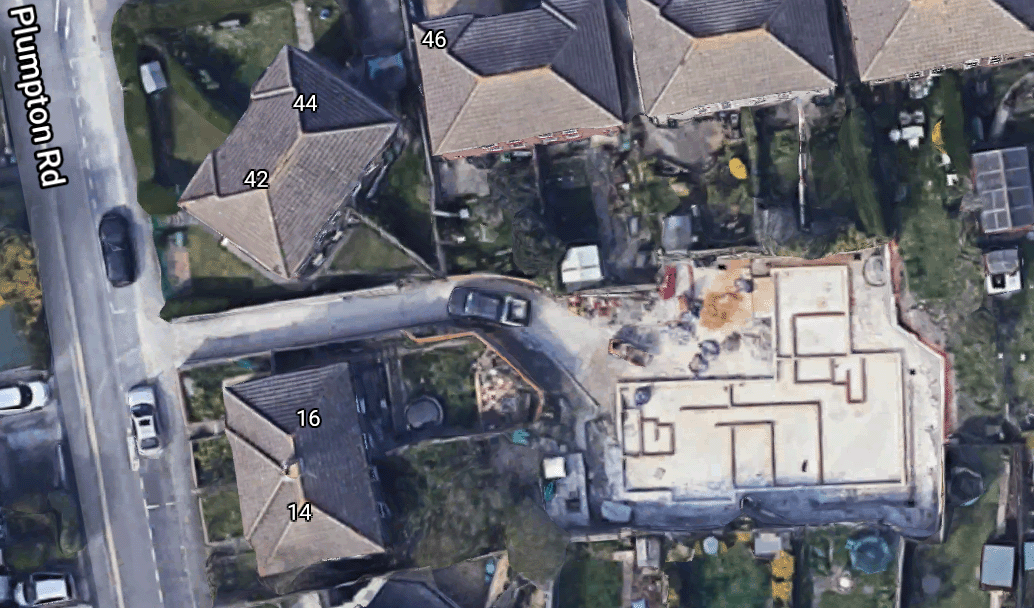 Nos 18-20 under construction [Google Maps] |
Pi1925— |
| Plymouth Avenue, Lower Bevendean BN2 4 |
Built around a wide sloping green, the south side was constructed in 1948 as the first post-war self-build project in the country, organised by A L Yerbury, comprising 20 three-bedroom houses costing £1,000 each. The north side was developed c1953-1955. Numbered 1 March 19521. | Ke1951— 1ESRO DB/D/27/355 |
| Poets' Corner | Area in Hove west of Sackville Road where streets are named after English, mainly Romantic poets: Byron, Coleridge, Cowper, Shakespeare, Shelley, Sheridan, Wordsworth. (Was this an estate agents' invention?) Immediately to the south-west are roads named after painters. Many of the houses were designed by local architect Thomas Lainson. A plan from late 1952 to develop the whole of this and adjacent areas with 'modern' tower blocks never went beyond the area around Ellen Street1. | 1Arscott (2002): 103 |
| Poets Mews | Gated development of four three-storey town houses, built in 2022 and accessed through an archway at 81 Shirley Street. | |
| † Pool | was a low-lying area at the southern end of the Steine (cf Pool Valley). | |
| † Pool Lane | This was the initial name of Pool Valley. †ph 6, The Catherine Wheel was an inn at the latter end of the 18th century. |
Co1799–Ba1822 |
| Pool Passage BN1 1 |
Twitten between 8 and 9 Pool Valley to 48 Old Steine. Gates were installed at either end in January 2023 to prevent anti-social behaviours. | Ke1932— |
| Pool Valley BN1 1 CA: Valley Gardens. |
Formerly known as Pool Lane, this was the point at which the Wellesbourne river reached the sea. But even after it was culverted beneath Old Steine in 1792, this area was liable to flooding—notable in 1850—hence the name. Improvements were made by Amon Henry Wilds in 18271 and the level of Grand Junction Road was raised by several feet in 1829 to keep the sea away. Further improvments were made by Allen Anscombe in 18402. Always an open area, it became a bus station in 1929 and is still used for coach services. The narrow western section, leading to East Street, is pedestrianised. [ph] 6 was a beerhouse called The Catherine Wheel from 1791 to 1818. [ph] 8 was the Bath Hotel from 1877 to 1884. 9 was built 1794, faced with mathematical tiles. Formerly a shop, it is now a residence (??) and Grade II* listed3 with the light standard to the rear. †ph 12 was a beerhouse called The Standard, listed in Ta1854 only.. †ph 14-15, Duke of Wellington was here before 1822 (Wellington was made a duke in 1814) and closed c1865. †ph 16 was the WHite Horse Shades from c1820 to 1869. †Royal Baths were opened in 1769 by Dr Awsiter when the vogue for sea-bathing was developing. They were owned by Mr Creak until acquired and demolished c1869/69 to make way for construction of Brill's Baths. Brills Royal Swimming Bath for Ladies next door to the gentleman's bath was opened in 1861 the Duchess of Cambridge and Princess Mary. It was 60ft long, 25ft wide with a ceiling height of 30ft and was the only sea-water bath for ladies in the country 4. Royal York Buildings has its entrance in Old Steine but the name is incorporated in this façade. 1  2 2 3 3 1. Creak's Baths; 2. a family group out at Pool Valley; 3. Royal York Buildings frontage in Pool Valley 4  5 5 6 6 4. demolition of Creak's Baths to make way for Brill's Baths; 5, 6. Brill's Baths January 1929; 7  8 8 9 9 7. early buses in Pool Valley, c1930; 8. the bus station in its heyday; 9. the entrance to the bus station from Old Steine was a challenge for drivers [Sources: 1, 4. RS James Gray Collection; 2, 5. Brighton & Hove Museums] |
Br1845— 1ESRO DB/D/52/48-50 2ESRO DB/D/52/51-53 3HE 1380721 4Illustrated London News 17 August 1861:163 |
| Pope's Folly, Preston (Hollingdean) BN2 4 |
At 2 Hollingdean Road. Built c1881 by Mr Pope. Covered reservoir probably dates from the late 1860s. Old Waterworks Allotments were established here at the beginning of the 20th century. Retreat, The. 1881. |
Pa1882— |
| ∫ Popham Road | Name for the section of Tongdean Road between Dyke Road Avenue and Tongdean Avenue prior to housing development.1 Popham was a surname in the family of WWilliam Roe, landowner of Withdean and Tongdean. | To1898–Pi1909 map 1Withdean Estate Plan. |
| Poplar Avenue, Hove BN3 8 |
The line of the road was determined by the presence of the Dyke railway branch line, which ran to the west of the road. | Ke1938— |
| Poplar Close, Hangleton BN3 8 |
Cul-de-sac off Northease Drive. | Ke1968— |
| Poplar Close, Preston BN1 6 |
Cul-de-sac off SurrendenRoad. | Ke1964— |
| Poplar Place | Once known as Ironmonger Lane when in The Hempshares, this was the former (popular) name for Meeting House Lane [qv for more details] but both names occur in the 1826 Ratebook. The name comes from a row of six poplar trees, cut down in 1872 but the identity is retained in a (damaged) tile-in-iron-frame street name [below]. The name plate now [David Fisher] |
Census1851; Pa1875:mdash; |
| ∫ Poplar Row | Alternative name for Poplar Place. | Co1799 |
| PORT HALL | Area to the east of Dyke Road, north of Old Shoreham Road, takes its name from Port Hall (116 Dyke Road). It is believed to have been the site of a Saxon burial ground. | |
| Port Hall Avenue BN1 5 |
Milligan House was built as the Port Hall Hotel PH in 1881, designed by A C Udney for Tamplin's brewery. An extension designed by Frank Tasker was added in 18871. It ceased to be a PH c1973 and was converted to residential use, then was a plumbers' merchants until 2017 and is currently a yoga studio. It is on the B&H local list. Milligan House/Port Hall Tavern |
Pa1883— 1ESRO DB/D/7/2495 (18 Aug 1887) |
| Port Hall Close | ||
| Port Hall Mews BN1 5 |
At the rear of 172-178 Dyke Road, where Port Hall Mill (also known as Cuttress's Mill) stood from 1795 or earlier until 1887. The yard was later used as a laundry and then for a garage1. | Ke1930— 1James Gray |
| Port Hall Place BN1 5 |
All houses were. 'Building' in 1883. Numbered 30 October 18841. 9-37 (odd) were designed by A C Udney for John Blaker2. 4-34 (even) were designed by A C Udney for John Blaker3 |
Pa1883— 1ESRO DB/D/27/220 2ESRO DB/D/2008 (4 May 1881) 3ESRO DB/D/2021 (1 Jun 1881) |
| Port Hall Road BN1 5 |
'Building' in 1883-1884. Re-numbered 1 October 18911. †Police Fire Brigade Station (call box) was on the corner of Port Hall Place (1908-1917). |
Pa1883— 1ESRO DB/D/27/241 |
| Port Hall Street BN1 5 |
'Houses building' in Pa1883. Numbered 30 October 18841. | Pa1883— 1ESRO amsgg/AMS6621/3/36 |
| ∫ Port Hall Terrace | Pa1883–Pa1885 | |
| Portfield Avenue, Withdean BN1 8 |
Numbered 30 July 19361. | Ke1936— 1ESRO DB/D/27/213 |
| Portland Avenue, Hove BN3 5 |
Pi1913— | |
| Portland Lane, Hove BN3 5 |
Cul-de-sac at 326 Portland Road, giving access to development behind Portland Villas, built c19101. | 1ESRO DO/C/6/3274 |
| Portland Mews BN2 1 CA: East Cliff. |
Now gated. The wall and gateway are Grade II listed1. | Census1851; Pa1892–Pa1895 1HE 1380854 |
| Portland Place BN2 1 CA: East Cliff. |
The name is from William Cavendish-Bentinkc, 3rd Duke of Portland, who was British prime minister in 1783 and again in 1807-1809
WEST SIDE 1-11 were designed by Charles Augustin Busby—part of his last work in Brighton—and built c1826 on land owned by Major Villeroy Russell. They are Grade II listed1. 10 was the residence of psychiatrist Sir Hubert Bond from 1925 until his death in 1945. NORTH SIDE 12-14 Pearson House replaced the Portland Place mansion of local landowner Major Villeroy Russell, a member of a branch of the Duke of Bedford's family, which burnt down on 12 September 1825, still uncompleted. The three houses then constructed were known as West House, Portland House and Portland Lodge respectively. Brighton College was temporarily houses in no 13 from January 1847 until the Eastern Road building was ready. No 12 was owned by the Hallett family for a number of years. The merged houses were re-named Pearson House after acquisition by the St Dunstans Institute at the end of the Great War. After next being vacated and renovated it became NHS Trust premises called Sussex House. It is Grade II listed2. EAST SIDE 15-25 are also by Charles Augustin Busby c1826 and are Grade II listed3. 15 was the Brighton residence of David Montagu Erskine, 2nd Baron Erskine. 1  2 2 1. Portland Place east side [Brighton & Hove Museums]; 2. The north end towards Pearson House. |
Br1845—; Census1851 1HE 1380722 2HE 1380723 3HE 1380724 |
| Portland Road, Hove BN3 5 |
Originally called Clarendon Villas Road between Sackville Road and Westbourne Street, then Bertram Road. It was renamed in 1894. The Dukes of Portland owned extensive lands in this area, developed from the 1870s onwards. NORTH SIDE (east to west) Convalescent Police Seaside Home was built in 1892, designed by J G Gibbins and built by William Willett at cost price. Thge foundation stone was laid by Princess Christian of Schleswig-Holstein, Queen Victoria's third daughter. With accommodation for 50 men, it was officially opened in 1893 by the Countess of Chichester. During WW1 it was an auxiliary military hospital and reverted post-war to use by the police until 1966. It is now a nursing home, known as Middleton Grove. It is on the B&H local list. Hove Methodist Church was designed with brick and terracotta in Gothic-Ramanesque style by John Wills. The memorial stone was laid on 3 June 1896 and the Wesleyan chapel opened in 1896, replacing an iron church with later additions. It is Grade II listed3. —Here is St Patrick's Road. 21-35 (odd) were designed by Thomas Lainson & Son and built in 1887 for Mrs Jane Hannah MacDonald as the Williamson Cottage Homes for Decayed Gentlewomen, which are also separately numbered. —Here is Westbourne Street. —Here is Rutland Road. —Here is Shelley Road. St Peter's Roman Catholic Church see Tamworth Road. —Here is Tamworth Road. ph 153, The Stoneham was built in 1895 as The Portland Hotel, designed by Scott & Cawthorn for Abbey, with further work by F T Cawthorn in 1903 and by Denman & Son in 1925 and 1927. It was given its current name c2010. Until then the eastern section has been called the Rock Bar and is currently a juice and coffee house called Pulp. —Here is Scott Road. †191-193 Granada Cinema was designed by H L Hemsley and opened on 17 July 1933 by the mayor of Hove, Victor Hudson, and attended by Anna Neagle. It was renamed the ABC in May 1965, closed 4 June 1974 and became the Lucky Seven Bingo Hall. In 1976 the Gala Bingo Hall was opened by actress Diana Dors. It finally closed in 2003 and became derelict. Demolished in 2012 and replaced by ... 193, Friese Greene House, a bizarrely-named housing and health care development in 2015. The glass is by Mel Howse. —Here is School Road. 197, West Hove Infant and Junior Schools —Here is Grange Road. 209, Elim Pentecostal Church was built in 1929. The foundation stone was laid by the founder of the Elim Foursquare Gospel Alliance, Principal George Jeffrey, on 21 February 1929. It is now a children's nursery. 211 was designed by G E Gower, with stabling at the rear, in 19284. —Here is Bolsover Road. —Here is Ingram Crescent East. —Here is Ingram Crescent West. Portland Business Park —Here is Olive Road. Portslade and West Hove Station. Originally opened on 12 May 1840 in a slightly different site on the west side of the level crossing but closed on 1 July 1847 for lack of use. Another station opened in October 1857, originally called Portslade, but a new station in an Italianate design was erected in 1881. It was renamed Portslade and West Hove in March 1927 but reverted to just Portslade on 12 May 1980. It is Grade II listed1. SOUTH SIDE (east to west) —Here is Westbourne Street. ph 90, The Westbourne was designed by Charles Blandford and built by Thomas Washington. It opened as the Aldrington Hotel in 1881. Further work was done by Samuel Denman in 1895 and Denman & Matthew added a billiard room in 1904. —Here is Westbourne Gardens. —Here is Rutland Gardens. —Here is Modena Road. —Here is Raphael Road. —Here is Titian Road. —Here is Reynolds Road. —Here is Hogarth Road. —Here is Raphael Road. —Here is St Helier Road. —Here is Coleman Avenue. 290, Noble Court flats, named in honour of Sgt Dennis Noble, who was killed when his Hawker Hurricane fighter plane crashed in Woodhouse Road. —Here is Woodhouse Road. †292-302, Portland Gate [right, image: RIBA] was designed by Joseph Hill and opened in 1940. It fell into disrepair and was demolished to be replaced by... 292-302, McNair Court flats, named in honour of Squadron leader Robin McNair. Built on the site of Portland Gate, a block of flats acquired by Nicholas Hoogstraaten, who allowed the buiding to be reduced to such a state that questions were asked in parliament; a Labour motion for compulsory purchase was voted down by the Consveratives in 1993 but was revived after Labour came to power in 1997 and succeeded. —Here is Portland Avenue. —Here is Mansfield Road. ph 324, Mansfield Hotel was designed in 1930 by Stavers Tiltman for the Portsmouth and Brighton United Breweries2. It was renamed the Golden Cross in the early 1960s and then the Jamaica Inn in 2003, Nobel House in 2012 and The Garden Bar in 2016. —Here is Jesmond Road. —Here is Rothbury Road. —Here is Portland Villas. —Here is Glebe Villas. —Here is Chelston Avenue. —Here is Leicester Villas. —Here is Worcester Villas. —Here is Blackberry Way. (Goodbye.) 1 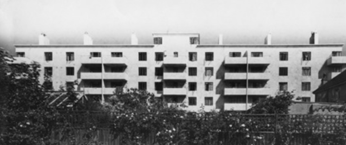 2 2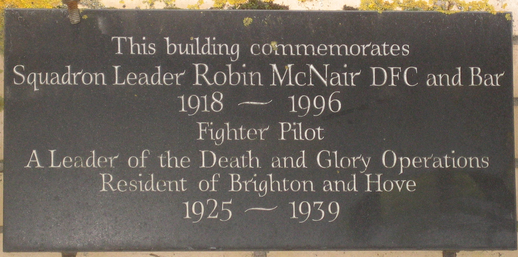 1. Portland Gate; 2. Plaque on McNair Court |
Pa1867— 1HE 1209609 2ESRO DO/C/6/7586 (21 June 1930) 3HE 1298647 |
| Portland Street BN1 1 CA: North Laine (3-19 and 42-45 consecutive). |
Number of properties in 1818: 18, in 1822: 21.> †ph 12 opened as The Cap of Liberty in 1843 and changed its name to the Brassfounders Arms three years later. It closed in 1926. |
Ba1822— |
| † Portland Street East | Fo1850–Pa1872 Census1851 |
|
| † Portland Terrace | Former name for (124 ?)127-133 Marine Parade. | |
| Portland Villas, Hove BN3 5 |
14 was designed by Mark Pellant of Koru Architects and built in 2017. | |
| ∫ Portland Villas, Kemp Town | Building in 1878. Numbered as College Road by 1880 | Pa1877–Pa1878 |
| † Portland Yard | Co1799 | |
| PORTSLADE | Portslade was part of the administrative area of Steyning East Rural District Council until 1898, when Portslade-by-Sea Urban District Council was established. This was merged into Hove Borough Council in 1974. In 1904 the lordship of the manor and the manor house were bought by Miss Kathleen Concepta Nelson1. |
1ESRO amsh/AMS5600/1 |
| Portslade Old Village CA | Conservation area, designated 1974, comprising 13.84ha (34.21 acres). | Character statement Map |
| † Poune's Court | Street which was on the west side of West Street below Boyces Lane, in which there was a synagogue. Later the Gas Company had the largest building. Poune was the local builder and timber merchant Stephen Poune. The first Jewish synagogue moved here from Jew Street in 1808 but was dissolved c.1813 when the size of the congregation fell, reviving again in 1821 until moving to Devonshire Place in 1824. | |
| Powis Grove BN1 3 CA: Clifton Hill. |
Built 1848-1853. For the origin of the name see Powis Villas. 11 had an ice house 18541. |
Ta1854— 1R G Martin: 'Ice Houses and the Commercial Ice Trade in Brighton' in Sussex Industrial History no 14: 21 |
| Powis Place | Fo1848—; Census1851 | |
| Powis Road BN1 3 CA: Clifton Hill. |
Built late 1860s. | Fo1852—; Census1861 |
| Powis Square BN1 3 CA: Clifton Hill. |
Built 1848-1853; 14 houses unoccupied or unfinished in 1852. This is Brighton's only inland Regency-style square. Brighton Corporation acquired the gardens by compulsory purchase in 1884 under the Brighton Improvement Act. Two K6 telephone kiosks at the west end are Grade II listed1. 1-11 and railings are Grade II listed2. 12 and railings is Grade II listed3. 13 and railings is Grade II listed4. 14-24 and railings are Grade II listed5.  Powis Square c1974 [David Fisher] |
Ta1854— 1HE 1380731 2HE 1380726 3HE 1380727 4HE 1380728 5HE 1380729 |
| Powis Villas BN1 3 CA: Clifton Hill. |
Built 1848-1853. 2-3 are Grade II listed1. 4, Grove House, originally Grove Villa, was built for Brighton ironmonger John Yearsley, who was born at Welshpool in Powys, Wales. He bought the land, which had been in the Kemp family since 1774, for £1,100 from the estate of Thomas Kemp after the latter's death in 1847. Grade II listed2. 5 and the coach house were donated in 1937 to the Royal Alexandra Hospital in Dyke Road. Grade II listed3. 6-7 were donated in 1937 to the Royal Alexandra Hospital in Dyke Road. Grade II listed4. 8-9 are Grade II listed5. 10-13 are Grade II listed6. |
Fo1850— 1HE 1380733, 1380734 2HE 1380735 3HE 1380736 4HE 1380737 5HE 1380738 6HE 1380740 |
| Poynings Drive, Hangleton BN3 8 |
One of a group of adjoining roads named after Sussex villages. | Ke1949— |
| Poynter Road, Hove BN3 7 |
Vallance Estate. One of five adjacent streets commemorating Victorian painters (the others being Frith, Landseer, Leighton and Prinsep). Sir Edward Poynter PRA (1836-1919) was an English Pre-Raphaelite painter, married to the sister-in-law of Edward Burne-Jones, the uncle by marriage of both Rudyard Kipling and Stanley Baldwin and President of the Royal Academy when the road was built c1905, having been laid out as early as 1896. | To1898— |
| † Preece's Buildings | Between Gardner Street and Regent Street. It was partially demolished in 1936 as part of the Brighton slum clearance programme but the now-gated entrance to the alley still exists adjacent to 100 Church Street.  Looking south towards Church Street. Photographed for Brighton Borough Council in 1935 by Vawdry 'to demonstrate those features of unfitness upon which the cases for clearance were based'. [Brighton & Hove Museums] |
Fo1848–Ke1936; Census1851 |
| Preston | 'Priests' farmstead' (OE preosta tun). One of the ancient manors and parishes in the area. Domesday Book records it as a possession of the Bishop of Chichester. Housing development from the 1860s onwards was principally the work of Daniel Friend. Formerly part of Steyning East Rural District, it was incorporated into the Borough of Brighton in 1928. | |
| Preston Circus BN1 4 |
1-7 were leased by Brighton Corporation to Lloyds Bank in December 1938. Duke of York's Cinema. Brighton's first purpose-built cinema opened on 22 September 1910 and is almost certainly the oldest purpose-built cinema in the country in continuous use. Designed by C E Clayton1 on the site of the former Amber Ale Brewery (see London Road). The cinema was founded by Mrs Violet Melnotte-Wyatt. She and her husband owned the Duke of York's Theatre in London. The name comes indirectly from Frederick, Duke of York and Albany (1763-1827) and long-time commander in chief of the army—the Grand Old Duke of York of the nursery rhyme—and younger brother of the Prince Regent. It is Grade II listed2. A 'second brass' coin of Otacilia (c248) was found during the cinema's construction3. Preston Circus Community Fire Station was designed by Graeme Highet, with relief panels by Joseph Cribb. The commission was offered in a competition in June 19354. It opened in 1938 and is on the B&H local list. |
Pi1908— 1ESRO DB/D/7/6419 (5 May 1910) 2HE 1380741 3HER ref 276 4ESRO ACC7600/24 (bundle misc 7/49) |
| Preston Drove BN1 6 CA: Preston Park (233-263 odd, 202-216 even, St Johns Church, Garage). CA: Preston Village (169, Preston Brewery Tap, 199-225 odd). |
Part of the drove road from Saltdean to Portslade, which continued via Middle Street, Preston to The Drove. It was numbered 19 May 19041, possibly when the name was changed, and 27 February 19362. NORTH SIDE west to east —Here is Preston Road. —Here is Bavant Road (at 31). —Here is Harrington Villas (at 49). —Here is Surrenden Road (at 69). 71, Park View [Hotel] was designed by Frank Cawthorn9 and was opened by Abbey (Kemp Town Brewery) in 1899. —Here is Balfour Road (at 99). —Here is Osborne Road (at 119). —Here is Lowther Road (at 137). —Here is Ditchling Road (at 269). SOUTH SIDE west to east —Here is Preston Road. Preston Manor manor was ceded to Queen Elizabeth in 1561 (value: £38 12s 4d). The lessee was Richard Elrington (d 1569), who was outlived by his wife Mary (née Isley), the widow of William Shirley of Wiston (c1498-c1551). She bequeathed the Preston estate to her second son, Anthony Sherley (c1546-1624). It stayed in the Shirley family until Sir Richard Shirley died in 1706 and the baronetcy became extinct. The estate was inherited by three sister co-heirs of Sir Richard—Anne, Mary and Judith. Anne married Robert Western and Mary his nephew Thomas. (Judith never married). The manor remained in the Western family from 1712 until sold in 1754 for £17,600 to William Stanford. His son William and then his grand-daughter Ellen inherited in turn. From Ellen's marriage to Vere Fane Benett came a son, John Montague Benett-Stanford but to prevent John inheriting and exploiting the estate, Ellen's second husband, Charles Thomas-Stanford, bought the manor from his wife's trustees in 1925 and gave it to the town on condition it remained a museum. In the same year the Corporation bought the frontage to Preston Drove and Preston Road for £5,000. Two elm trees in the grounds are believed to be the oldest in the world, dating from c.1150. Grade II* listed3 with the walls to the south-east7 and the ruined wellhouse (aka Donkey Wheel, c1735)8. St Peter's Church, in the grounds of the manor, dates from 1260—although there is a reference to a church here in Domesday Book—and has some medieval wall paintings, which survived a major fire in 1906, after which it was restored by P M Johnston. Heavily restored by James Woodman in 1872, with a south vestry and restored chancel by Ewan Christian of 1878. The church closed in 1988 and is in the care of the Churches Conservation Trust. It is Grade II* listed4, as are four tombs in the churchyard5 and the lamppost north of the entrance6. Preston Park [see below] at this point was formerly the International Gun and Polo Club Grounds before becoming the cricket ground by 1896. Wall postbox adjacent to the north-east gate into Preston Park bears the VR royal cipher. —Here is The Ride. —Here is Preston Park Avenue. —Here is Beaconsfield Villas (at 94). †Trams ran along the section from here to Ditchling Road. —Here is Havelock Road (at 94). †Neolithic long barrow may have been here. When levelled in 1891 two human bones were found. From OS1873 its size is estimated at 260 ft long, 35 ft wide and 12-15 ft high10. —Here is Waldegrave Road (at 94). —Here is Chester Terrace (at 94). —Here is Cleveland Road (at 94). Blaker's Park was a gift to the town by Alderman J G Blaker that opened on 3 November 1894. It retains most of its original design. The clock tower was added is 1896 and the tennis courts in the 1930s. The park and the clock tower are on the B&H local list. —Here is Southdown Road (at 94). —Here is Edburton Avenue. —Here is Ditchling Road (at 269). |
Pa1882— 1ESRO DB/D/27/104 2ESRO DB/D/27/5 3HE 1380750 4HE 1380743 5HE 1380745 6HE 1380748 7HE 1380751 8HE 1380752 9ESRO DB/D/7/4894 (17 Feb 1899) 10HER ref ES302 |
| Preston Park | Large park of 67 acres to the north of Brighton town centre but south of Preston was laid out in the mid 1880s on walled meadow land sold to Brighton Corporation in 1883 by Ellen Stanford of Preston Manor for £50,000. (It had been offered for £30,000 seven years earlier.) The money, including the £22,868 landscaping costs, came from a £60,000 bequest by local bookmaker William Edmund Davies. The park was officially opened on 8 November 1884 by the mayor, Alfred Cox. In the latter part of the 19th century, the International Gun and Polo Club Grounds were next to Preston Drove between Preston Park Avenue and the Preston Manor grounds, where the running track is now at the north-west end of the park. Polo games were played here by cavalry officers from Preston Barracks in Lewes Road until 1939. Clock tower, designed by borough surveyor Francis May, was unveiled by the mayor, Joseph Ewart on 17 June 1892. It was funded by Edward White, whose initials are on the tower. It is Grade II listed1. Octagonal Pavilion to the west of the basketball courts, built 1891/92, is Grade II listed2. On the south-west side a statue commissioned by Brighton Council from Peter Webster to the Olympic medal-winning athlete Steve Ovett was unveiled in 1987 and was then the most expensive public sculpture in the city, having cost £25,000; it was sawn off and stolen on the first weekend in September 2007, only the right foot remaining. The Rockery on the other side of the main road was created in 1935 from wooded land where rooks gathered, giving its original name of The Rookery (see also 187 Preston Road). It is the largest municipal rock garden in the country. |
1HE 1380948 2HE 1380949 |
| Preston Park CA | Conservation area, designated 1970 and extended in 1977, 1980 and 1981. It was split from Preston Village in 1988 and further extended in 1995; now comprising 86.8ha (214.47 acres). | Character statement Map |
| Preston Park Avenue BN1 6 |
Houses unoccupied in 1881-831, slowly developing later in the decade. Part numbered 7 March 19012. 5b, Yew Tree House, an eco back development, was designed by Bill Dunster Architects and ZEDfactory (for Zero Energy Development) in 2010. 39 was the billet where in 1944 Rex Whistler painted Allegory: HRH the Prince Regent Awakening the Spirit of Brighton (dated 5-7 June 1944) and King George IV in oils on the wallpaper. The paintings were removed and are now in Brighton Museum and Art Gallery. Whistler Court commemorates Rex Whistler. |
Pa1881— 1Pa1881,1883 2ESRO DB/D/27/173 |
| Preston Park Station | See Clermont Road. | |
| Preston Road BN1 4 |
The continuation of London Road between Preston Circus and near Towergate. Main development was in the late 1870s. Numbers were added to house names in the late 1880s. Much of the west side was redeveloped in the post-war period with large buildings. For about 30 years from 1765 there was a tea garden among the elm trees on the south side of the junction with Preston Drove, adjacent to Preston Manor. WEST SIDE 5-31 (odd) were designed by Thomas Simpson in 18757. Several have been remodelled and 23-29 replaced. 17 was the residence of successive builders and architects: George Buster (c1885-1886), William Parnacott (1886) and James W Hawker (1901). 33-81 (odd) were known as 1-25 Roseneath Terrace 1873-1875, until incorporated into the numbering of Preston Road. Railway viaduct was built in 1846. It was damaged by a bomb during a raid by a squadron of 24 Focke Wulf 190 fighter-bombers on 25 May 1943, which left a section of track hanging in the air3. It is Grade II* listed4. 87, Preston Road Board Schools are now part of Brighton Metropolitan College. It is on the B&H local list. —Here is Dyke Road Drive.] Houses north of Dyke Road Drive had names until they were allocated numbers later in the 1880s. The sequences from south to north are as follows, with the house numbers given later and the year when first listed in a street directory. 103 Parkmore. 1883 105 Evelyn House. 1883 107 Hillmara House. 1883 Anston House, which fell into disuse in 1987, was voted the ugliest building in Sussex in 2003. Villas listed in 1880 (all lost): 131 The Elms. 133 Arlington. 135 Aberdare. 137 Drumravery. 139 Lea Mount, renamed Sea Mount by 1882 141 Denmark House . 143 Hatherly. 145 Woodleigh. 147 Holmwood. Most of the following remained unnumbered until at least 1901 149 Brandon House. 151 Eskdale. 153 Streatley, renamed Stonleigh by 1882. This was the residence of Daniel Friend by 1891 until his death in 1902. 155 Cheribon. 1889. 157 The Limes. 1878. 159 Joy Villa. 1877. Mountjoy Villa. 1880. Not in 1882 161 Ferndale. Built 1877 for H Stafford Smith. Demolished 1985. 163 Spring Croft. 1878. 165 Belmont, originally a gentlemen's school. 1878, later the residence of a builder called Ben Saunders, who donated the house to become Kitchener's Home for Soldiers' and Sailors' Children, for orphans that received war pensions. 167 The Grove. 1880. —Here is Lover's Walk] 169 Sunnyside, 1877, renamed Scotia by 1901. 171 Burnfoot. 1880. 173 Mount Rose . 1878, renamed Montrose by 1882. 175 Carisbrooke. 1878. Glendale gentlemen's school. 1878-1879 only. May have become Kenmare. Kenmare. 1880. 179 Box Grove. 1877. 181 Fairlight. The residence of William Stroudley. 1878. †Bosviga and its lodge were the residence of William Stroudley. 1880-82. Renamed The Rookery. Preston Grange 10-storey apartment block is now on the site. Fernside. 1887 only. Ashlyn. 1901. Parkside. 1901. †ph 195, Black Lion was opened by Tamplin by 1871. A petrol station extension now occupies the site. —Here is South Road.] ph 197, Preston Brewery Tap, replacing a clapboard brewery building, was designed by Samuel Denman and built in 1888 adjoining the brewery (see Preston Village Mews). It was bizarrely renamed The Woof in 2024 but closed. 199, Acacia House was built of knapped flint as a farmhouse in the mid-18th century. A house had previously stood on this site since at least 1617. In the late Edwardian period it became a dining room and is now occupied by a firm of solicitors. Grade II listed1. The freehold, with the Brewery Tap (above) sold for £4,000 in November 18887. 201-205 (odd) were designed by Charles Stanley Peach (see also Lauriston Road). The gable of 201-203 is decorated with two bas-relief cockerels. They are on the B&H local list. —Here is Middle Road. —Here is North Road. ph 213, Crown & Anchor has been here since no later than 1711. It was here that the inquest on Celia Holloway (see Lover's Walk) was held in 1832. The Preston Parish Workhouse stood at the rear. A new hotel was designed by Nye and built by Smithers & Sons in 1886, with bed and breakfast accommodation, a gymnasium and the Preston Assembly Hall at the rear. The gymnasium, where noted boxers including Tommy Farr, Terry Downes and Don Cockell trained, was demolished in the 1960s. 215, 217, 219 were designed by A C Udney in 18945. 227-231 were bombed during the Second World War. No 231 was designed by C S Peach6. —Here is Cumberland Road. 253, Preston Court was the childhood residence of interior decorator Herman Schrijver (1904-1972). Here is Clermont Road. 257 Whitchurch House. -1910. 259 Clifton Villa. -1910. 261 Clyde Villa. -1910. †267 Tivoli was built c1900 and bought by Brighton Borough Council from Mrs May Rosetta Lansbury on 11 October 194813. Continues as London Road. EAST SIDE ph 2, The Joker was built for Kemp Town Brewery as the Stanford Arms PH in 1873 and refurbished by Denman & Son in 1927. It was later called CircusCircus and is on the B&H local list. 40 was the premises of Magnus Volk, electical engineer, from when first listed in 1878 to 1883. —Here is Ditchling Rise.] †66 was Balliol House. 1878. † Between Springfield Road and Stanford Avenue Claude Villa. 1883. 94 Bicton House. 1881. 96 Park Gate. 1883. 108 Preston Park Lodge. 1883 —Here is Stanford Avenue. —Here is Preston Park. 216, Preston Park Hotel was formerly Lourdes Convent Board and Day School. See St John's Villa and Woodslee below. Continues as London Road. A series of villas occupied the east side from the then borough boundary behind Harrington Road to about where Withdean Crescent is now. From south to north these houses were called Grove Lodge, St John's, Woodslee, Hartford Villa, Withdean Lodge (which itself had a lodge/gatehouse on Preston Road), Withdean House, Fir Croft, Effingham Lodge, Laine House and Withdean Hall. Effingham Lodge, Fir Croft and Laine House were three adjacent Victorian villas built c.1860 that were acquired by Brighton Corporation and sold for development. They were demolished c.1972 and the Varndean Drive ('Golden Acres') estate was built on the site. Manor Farm. 1881. Mounfry. 1881. The Mount. 1881. Preston House, to the east of the road, was a residence of Anne of Cleves, one of the wives of Henry VIII. (??) Rossmore. 1881. Rowden. 1881. Withdean Hall. See The Approach. †Withdean Lodge was a substantial Victorian villa in grounds of about four acres built in the 1860s when it was owned by the Misses Gregory, five sisters of whom two founded a home for lost and starving dogs (see 2-4 Robertson Road). The house was requisitioned for troop billets during the Second World War. It was demolished at the same time as Cliveden and the Grosvenor Court flats were built on the site. The round lodge house, which could be mistaken for a toll booth, the stable block and vinery remain. A drinking fountain in memory of Juliana Gregory was placed by the remaining sisters in 1897 further north, close to Surrenden Field. 216, Preston Park Hotel was originally a private house called Selbourne, then Norbury. After the widening of London Road in the mid 1930s it became the Methuen House Nursing Home and in the 1960s a hotel. Church of St John the Evangelist at the corner of Knoyle Road was built in the garden of the vicarage of St Peter's church (see Preston Drove). It was designed by Sir A W Blomfield & Sons and dedicated on 26 October 1902. It became the Preston parish church in 1908. Grade II listed2. Preston Lawn Tennis and Croquet Club has been on the north corner of Preston Drove since c.1925. The city council owns the site. Towergate flats were built on the site of Tivoli House, which was demolished in September 1988, and in the grounds of Tower House [qv], which in turn had formed part of the pleasure grounds that stretched westwards from London Road to beyond the railway line. First opened as Strawberry Tea Gardens in the early 1830s, they became Tivoli Gardens in 1852—taking the name ultimately from at Villa d'Este the gardens near Rome, although the name Tivoli was also used for fashionable gardens in Paris and Copenhagen, the latter having been so named as recently as 1843. |
Pa1877— 1HE 1380754 2HE 1380756 3Wikipedia 4HE 1380757 5ESRO DB/D/7/4059 (4 Oct 1894) 6ESRO DB/D/7/3057 (1 Mar 1894) 7The Builder, 24 Nov 1888:383 |
| Preston Street BN1 2 CA: Regency Square. |
Originally called Bedford Row9, mostly built 1820s. Renumbered 18 August 18911, 6 April 18992 and 7 May 19013. Numbering is consecutive from the south-west corner returning down the east side. WEST SIDE south to north 5 is Grade II listed4. [ph] 12-13 was the New Pier Tavern from 1868 to 1960; 13 had previously (1839-1843) been the London Eating House. [ph] 45, Chequers was opened by Kemp Town Brewery in 1854. It has had an identity crisis since 2016, becoming the Tipsy Bear in 2018, Oast in 2021, The Brick in 2022 and the Lankan (a Sri Lanka restaurant) in 2023. [ph] 49 was a beerhouse from 1846 to 1854. —Here is Western Road (at 52) EAST SIDE north to south [ph] 53 was a beerhouse from 1846 to 1853 —Here is Stone Street (at 56) 58 is Grade II listed5. 59 was the boarding house featured in Hilda Lessways (1911), the second volume of Arnold Bennett's Clayhanger trilogy. 'No. 59 was not even semi-detached, but one of a gaunt, tall row of stuccoed and single-fronted dwellings. It looked like a boarding-house, and ... not all the style of George Cannon's suit and cane and manner, as he mounted the steps, nor the polish of his new brass-plate, could redeem it from the disgrace of being a very ordinary boarding-house.' 60 is Grade II listed6. —Here is Castle Street (at 61) ph 66, Royal Sovereign Hotel opened by 1824. It is Grade II listed7. —Here is Regency Mews 67 was built c1818 and is probably by Amon Wilds and Amon Henry Wilds. Grade II listed with 22-25 Regency Square8. Birthplace of actress Eva Moore. —Here is Regency Square 79 Regency Cottage dates from the 1820s and is probably by Wilds and Busby. Grade II listed 10. Sovereign Inn. 1851. |
Ba1822— 1ESRO DB/D/27/240 2ESRO DB/D/27/126 3ESRO DB/D/46/679 4HE 1380758 5HE 1380759 6HE 1380760 7HE 1380761 8HE 1380834 9James Gray 10HE 1380762 |
| Preston Village CA | Conservation area, designated 1970 and extended in 1977, 1980 and 1981. It was split from Preston Park in 1988; now comprising 32.58ha (80.51 acres). | Character statement Map |
| Preston Village Mews BN1 6 |
Group of 14 houses around a courtyard, built between Middle Road and South Road in 1996 by T J Braybon & Son on the company's builder's yard, on the site of coal merchant's yard amd a brewery that is reflected in the name of the Preston Tap pub (formerly Brewery Tap) on Preston Road. The brewery dated back to the 18th century and was owned by local landowner Bartholomew Smithers. | |
| Prestonville | The middle-class housing development north of Seven Dials in the southern part of Preston village with the coming of the railway attracted this name. The principal developer was Daniel Friend. There appears to have been an extensive pagan Saxon burial ground in the area (see Stanford Road). | |
| Prestonville Road BN1 3 |
Built by Daniel Friend in the 1860s. The southern section was formerly known as Cobden Place. 2 Eric Gill lived here in childhood 1884-18861. 15 was the birthplace of C B Cochran. Plaque. |
Pa1881— 1(autobiography) |
| ∫ Prestonville Terrace | Under construction c1865-1868. Incorporated into Old Shoreham Road 30 August 19381 and numbered as 14-62. | Pa1881— 1ESRO DB/D/27/47 |
| Prince Albert Street BN1 1 CA: Old Town. |
Plan for laying out of new road is dated 5 November 183912, subsequently named in honour of Prince Albert of Saxe-Coburg and Gotha. Built 1842-47. Numbering is sequential from the south-east corner. SOUTH SIDE east to west —Here is Bartholomews. 1-8 were built c1842 and are Grade II listed1. ph 1-3, The Mesmerist was opened by the Laine Brewery Co with this name c2010. —Here is Black Lion Street. 10-13 were terraced houses dating from the late 18th century, now shops. Grade II listed2. 14 was partly renumbered as 13a and 13b 20 October 18923. —Here is Ship Street. 15 is Grade II listed4. 15b is a shop of the 1890s and is Grade II listed5. —Here is Meeting House Lane. †ph 16 was listed as a beerhouse called The Post Office in Ta1854 only. 16 was included in the Nile Pavilions Development by Robin Clayton Partnership (1989) and is Grade II listed6. —Here is Nile Street. 17-17a are Grade II listed7. 18-19 were built c1840 and are Grade II listed8. 20, 21, 21a and 21b are Grade II listed9. 22-23 are Grade II listed with 1 Nile Street10. 24 is Grade II listed with 41-41a Market Street11. —Here is Market Street. |
Br1845— 1HE 1380763, 1380764 2HE 1380765, 1380766 3ESRO DB/D/27/219 4HE 1380767 5HE 1380768 6HE 1380769 7HE 1380770 8HE 1380771 9HE 1380772 10HE 1380773 11HE 1380766 12ESRO DB/D/52/96 |
| Prince Regent's Close BN2 5 |
Cul-de-sac off Bristol Gardens. | Ke1964— |
| Princes Avenue, Hove BN3 4 CA: Pembroke and Princes. |
Road laid out by Clayton & Black for the Vallance Estate trustees, planning application dated 30 December 19021. | Pi1912— 1ESRO DO/C/6/2374 |
| Princes Crescent, Brighton BN2 3 CA: Round Hill. |
No houses in 1859-1871; the first appear in 1872. | Fo1859— |
| Princes Crescent, Hove BN3 4 CA: Pembroke and Princes. |
Built around 137 Kingsway, which was originally designated 1 Prince's Crescent. Renumbered 20 April 18811 and 27 March 18842. | Pi1927— 1ESRO DB/D/27/191 2ESRO DB/D/27/236 |
| Prince's Place BN1 1 CA: Valley Gardens. |
Leading from the Chapel Royal into the south end of the Royal Pavilion estate, the name was in use before 1799. Number of properties in 1822: 10. It was renumbered 22 May 19191. †4 was the premises of William Prince, 'organist and music-maker' in 1799. Regent House was designed by John Leopold Denman in neo-Georgian style and built in 1934. The inset relief carvings of George IV and Queen Caroline are by Joseph Cribb. †Pavilion Dormitories were on the east side, replaced by Princes House (see North Street).  Looking south towards North Street in 1933. The former dormitories are on the left. The corner of Braybon's showhouse in North Street can just be seen at right centre [RS James Gray Collection] |
Co1799— 1ESRO DB/D/27/82 |
| Princes Road BN2 3 CA: Round Hill. |
Numbered 20 April 18811. | Pa1880— 1ESRO DB/D/27/182 |
| Princes Square, Hove BN3 4 CA: Pembroke and Princes. |
Pi1917— | |
| Prince's Street BN2 1 CA: East Cliff. |
Formerly (1799) ran at right angles to Pavilion Parade. 18-20 are Grade II listed1. Former Parochial Offices of the Board of Guardians and Registrar were designed by Nunn & Hunt, are dated 1894 and opened May 1895. The name is carved above the entrance. Grade II listed2. |
Co1799— 1HE 1380774 2HE 1380776 |
| Prince's Terrace BN2 5 |
Back of Sussex Square. Numbered 23 May 19351. 1-6 were designed by Samuel Denman2 in 1894 as part of a group that originally included 10 houses. 7-10 were designed by Denman & Matthew in 19023. |
Pa1870— 1ESRO DB/D/27/15 2ESRO DB/D/7/3087 (7 Jun 1894) 3ESRO DB/D/7/5480 (1 May 1902) amended /5606 (10 Nov 1902) |
| Prinsep Road, Hove BN3 7 |
The southernmost of five adjacent streets commemorating Victorian painters, construction of which had begun by 1896. Val (Valentine Cameron) Prinsep RA (1838-1904) was an Indian-born English pre-raphaelite painter and nephew of the photographer Julia Margaret Cameron. The other painters are Frith, Landseer, Leighton and Poynter). | Pi1901— |
| ∫ Prospect Place | Former name for St Peter's Place. Number of properties in 1822: 4. | Ba1822 |
| ∫ Prospect Row | Former name of the section of St James's Street between George Street and High Street (late 1790s). It included a temporary catholic mission until a chapel was built 1806/07 in High Street. | Co1799 |
| Providence Place, Brighton BN1 4 |
Formerly continuing south to Cheapside, the section south of Ann Street is now half its original length; property on the west side was demolished and the site 'landscaped' behind railings, which were removed and replaced by steps c2015. North of Ann street, the street remains squalid. †St Bartholomew's School was built on 1874 and demolished in 1975, replaced by a new school in Ann Street. †27-29 were compulsorily purchased by Brighton Borough Council in 1967-1972 as part of the London Road relief scheme1. †ph 41, Malt & Hops opened in 1871 and closed in 1909/ 56, Promenade Student Living was built in 2024. |
Fo1848— 1ESRO DB/A/1/827 |
| † Providence Place, Hove | Opposite the gas works. Approximately where the archway is in Cornelius House in Church Road. |
Fo1850–Pi1897 |
| † Providence Place, Portslade | Off Station Road. |
Pa1890 |
| Pudding Bag Wood | On the south-west side of Stanmer Park, it includes three sites scheduled as National Monuments by English Heritage: earthworks that formed a prehistoric (possibly neolithic) linear boundary1 with a Bronze Age bowl barrow2 and the site of a round barrow3. | 1HE 402124 2HE 402081 3HE 1343881 |
| Pulborough Close, Whitehawk BN2 5 |
Cul-de-sac off Whitehawk Way. Pulborough is a town in West Sussex. | |
| † Pym's Gardens | See Pimm's Gardens |
Streets beginning with
A B C D E F G H I J K L M N O P Q R S T U V W X Y Z
Page updated 3 June 2026